


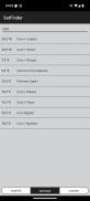
SatFinder


คำอธิบายของSatFinder
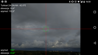
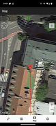
SatFinder (Finder ดาวเทียม) เป็นเครื่องมือที่จะช่วยให้คุณสามารถตั้งค่าจานดาวเทียม มันจะทำให้คุณราบสูงและ LNB เอียงสำหรับตำแหน่งของคุณ (ขึ้นอยู่กับจีพีเอส) และได้รับการแต่งตั้งจากรายการดาวเทียม ผลที่ตามมาก็แสดงให้เห็นทั้งสองเป็นข้อมูลที่เป็นตัวเลขและกราฟิกบนแผนที่ Google มันยังได้สร้างเข็มทิศในซึ่งจะช่วยให้คุณหาราบดาวเทียมที่เหมาะสม นอกจากนี้ยังสามารถใช้ความเป็นจริงยิ่งที่จะแสดงที่เป็นดาวเทียมในมุมมองของกล้อง
เข็มทิศทำงานได้เฉพาะบนอุปกรณ์ที่มีเซ็นเซอร์เข็มทิศ (magnetometer)
วิธีการใช้ app นี้:
1. ก่อนอื่นคุณควรเปิดใช้งาน GPS และอินเทอร์เน็ตบนมือถือของคุณ จำ - ในกรณีส่วนใหญ่มันเป็นไปไม่ได้ที่จะได้รับสัญญาณจีพีเอสภายในอาคาร ดังนั้นหากคุณต้องการที่จะได้รับตำแหน่งที่แม่นยำมาก - โปรดไปใกล้หน้าต่างหรือไปแม้ภายนอก
ในการตรวจสอบตำแหน่งปัจจุบันรุ่นควรจะพบค่อนข้างทันที ดังนั้นหากคุณติดอยู่กับ 'ตั้งไม่' ข้อความโปรดตรวจสอบให้แน่ใจว่าคุณได้เปิดใช้งานคุณลักษณะทั้งหมดที่จำเป็น / สิทธิ์
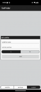
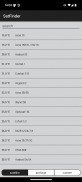
2. หากแอปพบตำแหน่งของคุณคุณต้องเลือกดาวเทียมที่ต้องการ การทำเช่นนี้คุณจะต้องพบกับไอคอนที่มีกระจกขยายและแตะมัน ในรายการที่คุณจะได้พบกับดาวเทียมทั้งหมดที่มีมุมเงยเหนือศูนย์องศา จำเอาไว้: ชื่อดาวเทียมไม่ได้ส่งผลกระทบต่อการคำนวณมุม สิ่งที่สำคัญคือตำแหน่งดาวเทียม
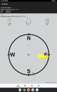
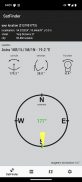
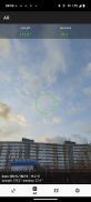
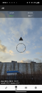
3. ราบระดับความสูงและมุมเอียงมีการคำนวณสำหรับสถานที่ของคุณและเลือกช่องสัญญาณดาวเทียม ภายใต้ค่าที่คำนวณมีเข็มทิศที่มีการแสดงกราฟิกของมุมราบ มุมราบมีการคำนวณที่มีความโน้มเอียงแม่เหล็ก จำ - ทุกครั้งที่คุณใช้เข็มทิศ - คุณควรสอบเทียบ สายสีเขียวหมายถึงราบโทรศัพท์ของคุณ ดังนั้นหากในเข็มทิศชี้วัดสีเขียวและสีแดงอยู่บนแต่ละอื่น ๆ - ด้านหน้าของโทรศัพท์ควรแสดงทิศทางไปยังดาวเทียม ถ้าค่าเข็มทิศที่ถูกต้อง - ค่าโทรศัพท์ราบจะไปสีเขียว
SatFinder--เวอร์ชั่น1.49
(17-08-2024)

SatFinder - ข้อมูล APK
เวอร์ชั่น APK: 1.49แพ็คเกจ: com.esys.satfinderเวอร์ชั่นล่าสุดของSatFinder
เวอร์ชั่นอื่น


แอปในประเภทเดียวกัน

คุณอาจจะชอบ...


